Where nobody is listening
A ground receiver hears aircraft a few hundred kilometres out. Over oceans, deserts or taiga that leaves hours of silence. Air traffic control has the same problem in the middle of the Atlantic: there is no radar out there, aircraft report their position over satellite links and controllers keep them much further apart than over land.
Since 11 August an aircraft whose destination we know keeps flying towards it on our map. It is drawn as an outline, it has no telemetry, and its detail panel says in so many words that the position is an estimate. On the morning of 1 October there were 2,515 such ghosts at once.
Not every aircraft that falls silent becomes a ghost. It has to be cruising, high and fast, with a destination we trust. One that disappears while descending is a few minutes from landing, and drawing it on at cruising height would be a lie.
A straight line isn’t enough
The shortest path across the globe is only a starting point. Real flights follow routes, and the routes change: the North Atlantic tracks are drawn up anew every day to suit the jet stream, which is why the trip east is usually about an hour shorter than the trip back. A real aircraft can be hundreds of kilometres off the ‘ideal’ line.
So the ghost learns from our own history. For every route we remember where aircraft came back into range of our antennas over the past weeks, and the ghost heads for that gate. Its detail says how many crossings the corridor was learned from and how much the gate varies, and if a route hasn’t been learned yet, it says plainly that the ghost is flying the great circle.
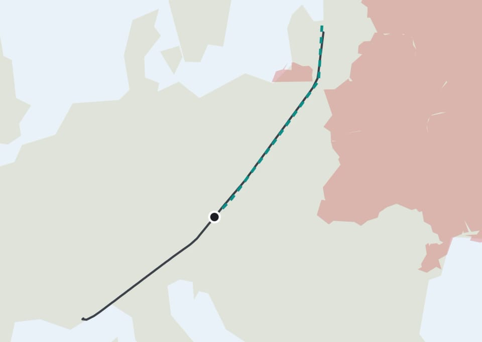
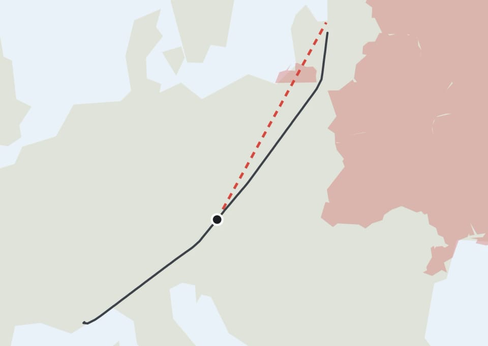
The same goes for the dashed line that runs on the map from the aircraft to its destination. For a long time it took the shortest path across the globe, and it caught us out. On Facebook someone pointed us to an airBaltic flight from Nice to Riga: the line went straight across Kaliningrad, where an airline from the European Union isn’t allowed to fly. And they were right. The real aircraft goes around it, usually to the east, over Lithuania.
Now the rest of the route comes from how the same route was actually flown in recent weeks. We draw a track an aircraft really flew, never an average: average one flight that passes Kaliningrad on the left with one that passes on the right, and you get a line straight through it. The chosen track is then joined to where the aircraft is right now. When nobody has flown the route yet, we draw the shortest path that goes around the countries closed to that airline: Russia and Belarus for European, British or American airlines, much of Europe and North America the other way round for Russian and Belarusian ones, and Ukraine for everybody. That comes from restrictions that are publicly known.
We measured it on fifteen routes, 158 flights. Halfway through each flight we let the estimate draw the rest and compared it with where the aircraft really went. The average miss fell from 171 kilometres to 32. Finnair from Helsinki to Tokyo, which goes around Russia either over the pole or by the southern route, went from 167 to 17 kilometres, and JAL from London to Tokyo from 328 to 36. Before, 37 percent of the estimates crossed a country the airline isn’t allowed into; now none do. Over the Atlantic, where the tracks are drawn up anew every day, the new estimate is only about as good as the shortest path. And the line stays dashed: it’s an estimate from earlier flights, not a flight plan.
A ghost must never pretend
A ghost lives for the whole flight, until its expected arrival plus a reserve for headwinds and holding. It is never older than the last real measurement: the moment any antenna picks the aircraft up again, the ghost is gone and the map shows a measured position.
If we are not sure where the aircraft is going, no ghost is drawn at all. A ghost never pushes a measured aircraft off the map either: when there are too many aircraft to draw, ghosts are the first to give way.
We also thought about the day something breaks. When one big station goes quiet, hundreds of aircraft in one region fall silent, but they are still flying, so ghosts take them over. When a whole stream of our data drops out and a large part of the entire map falls silent at once, no ghosts appear: they would hide the outage. Then the gap on the map is the truth.
And a ghost stays pale even when you colour aircraft by altitude. A ghost at cruising level gets the colour of its height, but keeps its faded outline, so it can never pass for a real fix.
Ghosts on the stands, and on the way there
The same question came up on the ground. After parking, crews switch the transponder off, and the aircraft disappears from every receiver even though it is still standing there. Now we keep it on its stand for several days, with a label that says how long it has been standing, or when we last saw it. We don’t claim it is definitely there. We claim when we heard it last.
When we extended how long parked aircraft are kept, the biggest jumps came at general-aviation airfields and cargo hubs, the places where aircraft wait for days.
On 1 October an Emirates A380 landed in Prague, and that wasn’t enough. The biggest airliner in the world is always an event there, and a lot of people were watching. Taxiing in at little more than walking pace, it fell silent a short way from its stand and vanished from the 3D view. With it went the best part: watching the steps, the fuel truck and the baggage carts drive up.
At a real airport, stands are planned in advance. The airport knows which aircraft is arriving, how big it is, which airline flies it and where it goes next, and gives it a stand that fits. The crew taxis there, stops on the line, and the transponder should go off only after that. Sometimes, though, it goes off earlier, while the aircraft is still rolling. And sometimes we are the ones who lose it: an aircraft on the ground sits low, and hangars, a terminal or a hill stand between it and our antennas.
Until now such an aircraft simply disappeared. So we built a way to bring it in. We work out where it is most likely heading: a free stand nearby that an aircraft of its size actually fits on, because an A380 won’t park on a stand built for a regional turboprop. Where we are allowed to read the airport’s departure board, the board helps too. An aircraft that has just landed will soon fly on, and the gate of its next departure gives away which stand it will be waiting at. In 3D we then drive it along the taxiways to that stand, it stops, and the ground equipment drives up as it would to any other aircraft.
It is an estimate and we label it as one: the aircraft says that its stand was worked out, not measured. If another aircraft that we can hear pulls onto that spot, our estimate gives way and the aircraft we brought there disappears. A real measurement always wins.
The next step is already under way. Aircraft heading to a given stand tend to take the same few routes: from the same runway to the same jet bridge they taxi much the same way every time. From aircraft we heard all the way in, we are learning which routes really lead to each stand, so that we can guide the silent ones along the most common of them. And where the departure board tells us the gate, we want to bring the aircraft to its own gate even if we never heard a single signal from it after landing.
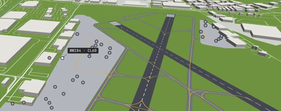
At Teterboro, where private jets wait for their passengers, the number of aircraft on the stands jumped from 28 to 76.